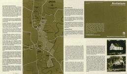
Antietam - The Bloodiest Day of the Civil War. This CD contains a large number of rare historic maps and descriptive pages, photos and a ballad representing fascinating details pertaining to the Battle of Antietam during the Civil War.
GENERAL ROBERT E. LEE'S first invasion of the North culminated with the Battle of Antietam, in Maryland (or Sharpsburg, as the South called it). The battle took place on Wednesday, September 17, 1862, just 18 days after the Confederate victory at Second Manassas, 40 miles to the southeast in Virginia.
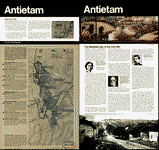
Not only was this the first major Civil War engagement on Northern soil, it was also the bloodiest single day battle in American history.
To view the magnitude of the losses, consider that Antietam resulted in nine times as many Americans killed or wounded (23,000 soldiers) as took place on June 6, 1944--D-day, the so-called "longest day" of World War II. Also consider that more soldiers were killed and wounded at the Battle of Antietam than the deaths of all Americans in the Revolutionary War, War of 1812, Mexican War, and Spanish-American War combined.
The loss of human life at Antietam shocked both sides doing battle that day. And it nearly resulted in Lee's entire army, with its back to the Potomac River, being cut off from retreat across the Potomac (through Shepherdstown) and being captured by the stronger Union forces.
The battle also became a turning point, an engagement that changed the entire course of the Civil War. Antietam not only halted Lee's bold invasion of the North but thwarted his efforts to force Lincoln to sue for peace. It also provided Lincoln with the victory he needed to announce the abolition of slavery in the South. And with that proclamation of Emancipation, Lincoln was able to broaden the base of the war and may have prevented England and France from lending support to a country that engaged in human bondage. The battle sealed the fate of the Confederacy.
Below is detailed the contents of the CD.
This CD contains a large number of rare historic maps and descriptive pages representing fascinating details pertaining to the Battle of Antietam during the Civil War in MrSid format. This format allows you to see the entire map on your computer screen or drill down to see the smallest details. The original maps are often quite large, as much as 36" long or larger and quite detailed. With the MrSID software, you can manipulate the map to print the entire map in great detail or zoom into a portion of the map in full detail for viewing or printing. You could even bring the images to a local print shop to have the maps reprinted in their full size. (MrSID software is included on the CD.)
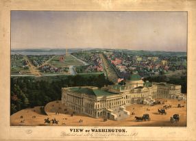
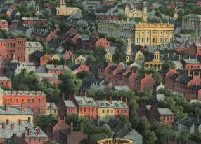
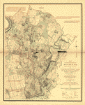
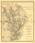
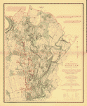
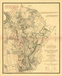
To give you a sample of the detail you can expect in these maps, here is an example based on a panoramic map of Washington, DC.
 |
 |
 |
 |
The table below shows the description and a small image of each map on this fascinating civil war history CD.
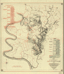
 The Battle of Antietam, September 17, 1862. United States. National Park Service. CREATED/PUBLISHED Washington, U.S. Govt. Print. Off., 1968. NOTES Scale not given. Shows the placement and movement of troops during 3 phases of the battle. The Battle of Antietam, September 17, 1862. United States. National Park Service. CREATED/PUBLISHED Washington, U.S. Govt. Print. Off., 1968. NOTES Scale not given. Shows the placement and movement of troops during 3 phases of the battle. |
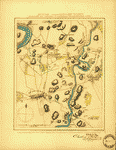
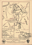
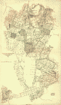
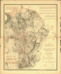
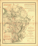
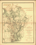
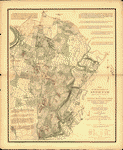
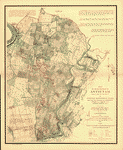
 Map of the battlefield of Antietam. No. 1. This map shows the position of the Union and Confederate forces on the morning of Sept. 17th, 1862, prior to the battle of Antietam which opened at daybreak Drawn under the direction of Antietam Board, Col. John C. Stearns, Gen. H. Heth. Theo. Friebus, Jr. Antietam Battlefield Board. CREATED/PUBLISHED Washington, D.C., Norris Peters Co., photo-litho., 1893. NOTES Scale 1:14,080. Confederate forces are shown in red and Union forces in blue. Headquarters of McClellan and Lee are clearly indicated. Legend lists the names of the corps, division, and brigade commanders. Brigades are keyed by number of positions on the map. Shows roads, railroad, houses, fences, names of residents, "Burnside Bridge," "Bloody Lane," "Dunker's Chapel," "National Cemetery," towns, vegetation, drainage, fords, and relief by hachures. Map of the battlefield of Antietam. No. 1. This map shows the position of the Union and Confederate forces on the morning of Sept. 17th, 1862, prior to the battle of Antietam which opened at daybreak Drawn under the direction of Antietam Board, Col. John C. Stearns, Gen. H. Heth. Theo. Friebus, Jr. Antietam Battlefield Board. CREATED/PUBLISHED Washington, D.C., Norris Peters Co., photo-litho., 1893. NOTES Scale 1:14,080. Confederate forces are shown in red and Union forces in blue. Headquarters of McClellan and Lee are clearly indicated. Legend lists the names of the corps, division, and brigade commanders. Brigades are keyed by number of positions on the map. Shows roads, railroad, houses, fences, names of residents, "Burnside Bridge," "Bloody Lane," "Dunker's Chapel," "National Cemetery," towns, vegetation, drainage, fords, and relief by hachures. |
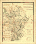
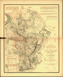
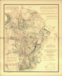
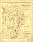 Map of the battlefield of Antietam with the locations of monuments erected by the Commonwealth of Pennsylvania Prepared for the Antietam Battlefield Memorial Commission. Reduced and drawn by S. A. Hammond, Asst. Eng. Antietam Battlefield Memorial Commission. CREATED/PUBLISHED N.Y., Julius Bien & Co., lith., 1908? NOTES Scale 1:18,000. "Reduced by permission of the Antietam Commission, Brig. Gen. E. A. Carman, Commissioner, from their map of the battlefield that was surveyed and drawn by the engineers of the Gettysburg National Park Commission, Lt. Col. John P. Nicholson, Chairman, Bvt. Lt. Col. E. B. Cope, Engineer." Detailed map indicating roads, drainage, fence lines, houses, names of residents, woodland, and relief by contour lines. Battlefield monuments are located by red squares. Map of the battlefield of Antietam with the locations of monuments erected by the Commonwealth of Pennsylvania Prepared for the Antietam Battlefield Memorial Commission. Reduced and drawn by S. A. Hammond, Asst. Eng. Antietam Battlefield Memorial Commission. CREATED/PUBLISHED N.Y., Julius Bien & Co., lith., 1908? NOTES Scale 1:18,000. "Reduced by permission of the Antietam Commission, Brig. Gen. E. A. Carman, Commissioner, from their map of the battlefield that was surveyed and drawn by the engineers of the Gettysburg National Park Commission, Lt. Col. John P. Nicholson, Chairman, Bvt. Lt. Col. E. B. Cope, Engineer." Detailed map indicating roads, drainage, fence lines, houses, names of residents, woodland, and relief by contour lines. Battlefield monuments are located by red squares. |
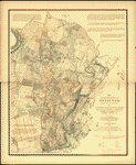
 Antietam Battlefield : new 1972 / National Park Service, U.S. Department of the Interior. United States. National Park Service. CREATED/PUBLISHED [Washington] : The Service, [1978] NOTES Scale ca. 1:23,500. Includes text and descriptive index to points of interest. Antietam Battlefield : new 1972 / National Park Service, U.S. Department of the Interior. United States. National Park Service. CREATED/PUBLISHED [Washington] : The Service, [1978] NOTES Scale ca. 1:23,500. Includes text and descriptive index to points of interest. |
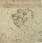
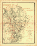
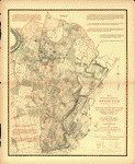
 (No. 2) Map of the battlefield of Antietam Drawn under the direction of Antietam Board, Col. John C. Stearns [and] Gen. H. Heth. Antietam Battlefield Board. CREATED/PUBLISHED Washington, D.C. The Norris Peters Co., photo-litho. 1894. NOTES Scale 1:14,908. Map of the battlefield showing roads and lanes, houses and names of residents, fences, drainage, woodland, and relief by hachures. Troop positions are not indicated. (No. 2) Map of the battlefield of Antietam Drawn under the direction of Antietam Board, Col. John C. Stearns [and] Gen. H. Heth. Antietam Battlefield Board. CREATED/PUBLISHED Washington, D.C. The Norris Peters Co., photo-litho. 1894. NOTES Scale 1:14,908. Map of the battlefield showing roads and lanes, houses and names of residents, fences, drainage, woodland, and relief by hachures. Troop positions are not indicated. |
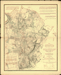
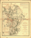
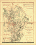
 Map of the battlefield of Antietam Published under the direction of Daniel S. Lamont and Russell A. Alger, Secretaries of War, by the Antietam Battlefield Board, Major Geo. W. Davis, U.S.A. President, General E. A. Carman, late Union army, [and] General H. Heth, late Confederate army. Surveyed and drawn by Col. E. B. Cope, Engineer [and] H. W. Mattern, Ass't Engineer, Gettysburg National Park. Antietam Battlefield Board. CREATED/PUBLISHED [S.l.] Antietam Battlefield Board 1898. NOTES Scale ca. 1:10,560. "Drawn by H. W. Mattern" in the lower right corner. "Note: Figures in black and crosses, thus (+) marked along roadsides indicate numbers of tablets. For legends on tablets showing positions of troops and their movements, see final report of the Antietam Battlefield Board to the Secretary of War, dated 1898." Detailed map of the battlefield showing roads, lanes, fences, houses, names of residents, woodland, and relief by contour lines at intervals of 10 feet. Troop positions are not noted. Map of the battlefield of Antietam Published under the direction of Daniel S. Lamont and Russell A. Alger, Secretaries of War, by the Antietam Battlefield Board, Major Geo. W. Davis, U.S.A. President, General E. A. Carman, late Union army, [and] General H. Heth, late Confederate army. Surveyed and drawn by Col. E. B. Cope, Engineer [and] H. W. Mattern, Ass't Engineer, Gettysburg National Park. Antietam Battlefield Board. CREATED/PUBLISHED [S.l.] Antietam Battlefield Board 1898. NOTES Scale ca. 1:10,560. "Drawn by H. W. Mattern" in the lower right corner. "Note: Figures in black and crosses, thus (+) marked along roadsides indicate numbers of tablets. For legends on tablets showing positions of troops and their movements, see final report of the Antietam Battlefield Board to the Secretary of War, dated 1898." Detailed map of the battlefield showing roads, lanes, fences, houses, names of residents, woodland, and relief by contour lines at intervals of 10 feet. Troop positions are not noted. |
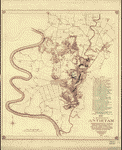 Map of the battlefield of Antietam. This map shows the position of each of the forty-two different commands of the regular army engaged in the battle of Antietam, September 17, 1862. Battery "G", 2d U.S. Artillery, Lt. J. H. Butler, commanding, was not engaged in the battle, being attached to Gen'l. Couch's Division, near Harper's Ferry Drawn under the direction of Antietam Board, Col. John C. Stearns, Gen. H. Heth. Theo. Friebus Jr. Antietam Battlefield Board. CREATED/PUBLISHED Washington D.C., Norris Peters Co., photo-litho., 1893. NOTES Scale 1:14,080. Legend lists Union commands and the names of the commanders. Each unit is keyed by number to a position on the map. Confederate positions are not indicated. Shows roads, railroad, houses, fences, names of residents, "Burnside Bridge," "Bloody Lane," "Dunker's Chapel," "National Cemetery," towns, vegetation, drainage, fords, and relief by hachures. Map of the battlefield of Antietam. This map shows the position of each of the forty-two different commands of the regular army engaged in the battle of Antietam, September 17, 1862. Battery "G", 2d U.S. Artillery, Lt. J. H. Butler, commanding, was not engaged in the battle, being attached to Gen'l. Couch's Division, near Harper's Ferry Drawn under the direction of Antietam Board, Col. John C. Stearns, Gen. H. Heth. Theo. Friebus Jr. Antietam Battlefield Board. CREATED/PUBLISHED Washington D.C., Norris Peters Co., photo-litho., 1893. NOTES Scale 1:14,080. Legend lists Union commands and the names of the commanders. Each unit is keyed by number to a position on the map. Confederate positions are not indicated. Shows roads, railroad, houses, fences, names of residents, "Burnside Bridge," "Bloody Lane," "Dunker's Chapel," "National Cemetery," towns, vegetation, drainage, fords, and relief by hachures. |
 Map of the battlefield of Antietam with the locations of monuments erected by the Commonwealth of Pennsylvania to the 3rd, 4th, 7th, 8th regiments of infantry, Pennsylvania Reserve Corps Prepared for Antietam Battlefield Commission of Pennsylvania. Reduced and drawn by S. A. Hammond, Ass't. Eng. Antietam Battlefield Memorial Commission. CREATED/PUBLISHED [S.l., 1908?] NOTES Scale 1:18,000. "Reduced by permission of the Antietam Commission, Brig. Gen. E. A. Carman, Commissioner, from their map of the battlefield that was surveyed and drawn by the engineers of the Gettysburg National Park Commission, Lt. Col. John P. Nicholson, Chairman, Bvt. Lt. Col. E. B. Cope, Engineer, H. W. Mattern, Ass't. Engineer, [and] E. M. Hewitt, Ass't. Engineer." Detailed map indicating roads, drainage, fence lines, houses, names of residents, woodland, and relief by contour lines. Inset: Mansfield Avenue enlarged to show positions of Pennsylvania Reserve monuments. 7 x 25 cm. Map of the battlefield of Antietam with the locations of monuments erected by the Commonwealth of Pennsylvania to the 3rd, 4th, 7th, 8th regiments of infantry, Pennsylvania Reserve Corps Prepared for Antietam Battlefield Commission of Pennsylvania. Reduced and drawn by S. A. Hammond, Ass't. Eng. Antietam Battlefield Memorial Commission. CREATED/PUBLISHED [S.l., 1908?] NOTES Scale 1:18,000. "Reduced by permission of the Antietam Commission, Brig. Gen. E. A. Carman, Commissioner, from their map of the battlefield that was surveyed and drawn by the engineers of the Gettysburg National Park Commission, Lt. Col. John P. Nicholson, Chairman, Bvt. Lt. Col. E. B. Cope, Engineer, H. W. Mattern, Ass't. Engineer, [and] E. M. Hewitt, Ass't. Engineer." Detailed map indicating roads, drainage, fence lines, houses, names of residents, woodland, and relief by contour lines. Inset: Mansfield Avenue enlarged to show positions of Pennsylvania Reserve monuments. 7 x 25 cm. |
 Antietam Battlefield. United States. National Park Service. CREATED/PUBLISHED Washington, U.S. Govt. Print. Off., 1972. NOTES Scale ca. 1:24,000. Includes text and index to points of interest. Antietam Battlefield. United States. National Park Service. CREATED/PUBLISHED Washington, U.S. Govt. Print. Off., 1972. NOTES Scale ca. 1:24,000. Includes text and index to points of interest. |
 Antietam / National Park Service, U.S. Department of the Interior. United States. National Park Service. CREATED/PUBLISHED [Washington] : The Service, [1980] NOTES Scale ca. 1:31,680. Folded title: Antietam National Battlefield, Maryland. Relief shown by shading. Includes text, descriptive index to points of interest, and location map. / National Park Service, U.S. Department of the Interior. United States. National Park Service. CREATED/PUBLISHED [Washington] : The Service, [1980] NOTES Scale ca. 1:31,680. Relief shown by shading. Includes text, descriptive index to points of interest, and location map. Antietam / National Park Service, U.S. Department of the Interior. United States. National Park Service. CREATED/PUBLISHED [Washington] : The Service, [1980] NOTES Scale ca. 1:31,680. Folded title: Antietam National Battlefield, Maryland. Relief shown by shading. Includes text, descriptive index to points of interest, and location map. / National Park Service, U.S. Department of the Interior. United States. National Park Service. CREATED/PUBLISHED [Washington] : The Service, [1980] NOTES Scale ca. 1:31,680. Relief shown by shading. Includes text, descriptive index to points of interest, and location map. |
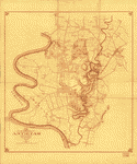
 Antietam Sharpsburg and vicinity. Constructed and engraved to illustrate "The war with the South" [Compiled by Charles Sholl] Engd. by Rae Smith. Sholl, Charles CREATED/PUBLISHED New York, c1864. NOTES Scale ca. 1:26,700. From Tomes, Robert. The war with the South. New York, Virtue & Yorston, 1862-1867, v. 2, between p. 426 and 427. Signed (facsim.): Charles: Sholl, Topl. Engineer. This issue lacks the copyright notice in the lower margin. Caption in lower margin: A topographical map of the battle field at Antietam from an actual survey by an engineer officer on General Doubleday's staff. Antietam Sharpsburg and vicinity. Constructed and engraved to illustrate "The war with the South" [Compiled by Charles Sholl] Engd. by Rae Smith. Sholl, Charles CREATED/PUBLISHED New York, c1864. NOTES Scale ca. 1:26,700. From Tomes, Robert. The war with the South. New York, Virtue & Yorston, 1862-1867, v. 2, between p. 426 and 427. Signed (facsim.): Charles: Sholl, Topl. Engineer. This issue lacks the copyright notice in the lower margin. Caption in lower margin: A topographical map of the battle field at Antietam from an actual survey by an engineer officer on General Doubleday's staff. |
 Antietam Sharpsburg and vicinity. Constructed and engraved to illustrate "The war with the South" [Compiled by Charles Sholl] Engd. by Rae Smith. Sholl, Charles. CREATED/PUBLISHED New York, c1864. NOTES Scale ca. 1:26,700. From Tomes, Robert. The war with the South. New York, Virtue & Yorston, 1862-1867, v. 2, between p. 426 and 427. Signed (facsim.): Charles: Sholl, Topl. Engineer. "Entered according to act of Congress AD. 1864 by Virtue, Yorston & Co." Caption in lower margin: A topographical map of the battle field at Antietam from an actual survey by an engineer officer on General Doubleday's staff. Antietam Sharpsburg and vicinity. Constructed and engraved to illustrate "The war with the South" [Compiled by Charles Sholl] Engd. by Rae Smith. Sholl, Charles. CREATED/PUBLISHED New York, c1864. NOTES Scale ca. 1:26,700. From Tomes, Robert. The war with the South. New York, Virtue & Yorston, 1862-1867, v. 2, between p. 426 and 427. Signed (facsim.): Charles: Sholl, Topl. Engineer. "Entered according to act of Congress AD. 1864 by Virtue, Yorston & Co." Caption in lower margin: A topographical map of the battle field at Antietam from an actual survey by an engineer officer on General Doubleday's staff. |
 Southwest, or no. 2, sheet of preliminary map of Antietam (Sharpsburg) battlefield. Enlarged from "Michler" map of the war records atlas with corrections and additions Antietam Battlefield Commission [sic] Maj. Geo. B. Davis, U.S.A., President, H. Heth, E. A. Carman, Expert Historian, [and] Jed. Hotchkiss, Expert Topographer. Antietam Battlefield Board. CREATED/PUBLISHED Washington D.C., The Norris Peters Co., photo-litho., 1895. NOTES Scale ca. 1:10,400. Map extends from Sharpsburg south to Antietam Iron Works and shows roads and lanes, houses and names of residents, fences, and drainage. Troop positions are not noted. Southwest, or no. 2, sheet of preliminary map of Antietam (Sharpsburg) battlefield. Enlarged from "Michler" map of the war records atlas with corrections and additions Antietam Battlefield Commission [sic] Maj. Geo. B. Davis, U.S.A., President, H. Heth, E. A. Carman, Expert Historian, [and] Jed. Hotchkiss, Expert Topographer. Antietam Battlefield Board. CREATED/PUBLISHED Washington D.C., The Norris Peters Co., photo-litho., 1895. NOTES Scale ca. 1:10,400. Map extends from Sharpsburg south to Antietam Iron Works and shows roads and lanes, houses and names of residents, fences, and drainage. Troop positions are not noted. |
 Battle of the Antietam fought September 16 & 17, 1862 Reconnoissance of the ground occupied by the 1st Army Corps commanded by Maj. Gen. Hooker. Made under the direction of Maj. D. C. Houston, Chf. Engr., by Lieut. W. A. Roebling and W. S. Long, C.E. Roebling, Washington A. CREATED/PUBLISHED [S.l., 1862] NOTES Scale 1:10,560. Pen and ink manuscript drawn on tracing cloth, showing "line of Hooker's advance," roads, houses and names of occupants, fences, vegetation, drainage, and relief by hachures. Troop positions are not given. Battle of the Antietam fought September 16 & 17, 1862 Reconnoissance of the ground occupied by the 1st Army Corps commanded by Maj. Gen. Hooker. Made under the direction of Maj. D. C. Houston, Chf. Engr., by Lieut. W. A. Roebling and W. S. Long, C.E. Roebling, Washington A. CREATED/PUBLISHED [S.l., 1862] NOTES Scale 1:10,560. Pen and ink manuscript drawn on tracing cloth, showing "line of Hooker's advance," roads, houses and names of occupants, fences, vegetation, drainage, and relief by hachures. Troop positions are not given. |
 Antietam national battlefield site, Maryland Drawn by John J. Black, November 1948. United States. National Park Service. CREATED/PUBLISHED [S.l.], reprint 1959. NOTES Scale ca. 1:54,000. Map indicates the main battle lines and the tour route. Inset: Vicinity map. 5 x 6 cm. Illustrates a descriptive leaflet by the U.S. National Park Service entitled "Antietam national battlefield site, Maryland." Antietam national battlefield site, Maryland Drawn by John J. Black, November 1948. United States. National Park Service. CREATED/PUBLISHED [S.l.], reprint 1959. NOTES Scale ca. 1:54,000. Map indicates the main battle lines and the tour route. Inset: Vicinity map. 5 x 6 cm. Illustrates a descriptive leaflet by the U.S. National Park Service entitled "Antietam national battlefield site, Maryland." |
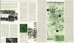
 The field of Antietam. Wells, Jacob. CREATED/PUBLISHED [S.l., 1886] NOTES Scale ca. 1:48,500. From Century illustrated monthly magazine, v. 32, June 1886. p. 290. Shows batteries, troop positions and movements, names of commanders, roads, street pattern of Sharpsburg, drainage, vegetation, relief by hachures, houses, names of residents, and fences. Chronology of events appears below the map. The field of Antietam. Wells, Jacob. CREATED/PUBLISHED [S.l., 1886] NOTES Scale ca. 1:48,500. From Century illustrated monthly magazine, v. 32, June 1886. p. 290. Shows batteries, troop positions and movements, names of commanders, roads, street pattern of Sharpsburg, drainage, vegetation, relief by hachures, houses, names of residents, and fences. Chronology of events appears below the map. |
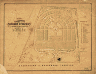 Map of Antietam National Cemetary at Sharpsburg, Maryland Designed by A. A. Biggs, M. D., President & Genl. Supt., Sharpsburg, 1866. Surveyed and drawn by Chas. P. Kahler, C. E., Baltimore. Kahler, Charles P. CREATED/PUBLISHED Balto., Lith. by A. Hoen & Co., 1867. NOTES Scale 1:600. "Entered according to Act of Congress in the year 1867 by the Board of Trustees of the 'Antietam National Cemetary' in the Clerks Office of the U.S. District Court for Maryland." 29 "references" are keyed by number to the map. Map of Antietam National Cemetary at Sharpsburg, Maryland Designed by A. A. Biggs, M. D., President & Genl. Supt., Sharpsburg, 1866. Surveyed and drawn by Chas. P. Kahler, C. E., Baltimore. Kahler, Charles P. CREATED/PUBLISHED Balto., Lith. by A. Hoen & Co., 1867. NOTES Scale 1:600. "Entered according to Act of Congress in the year 1867 by the Board of Trustees of the 'Antietam National Cemetary' in the Clerks Office of the U.S. District Court for Maryland." 29 "references" are keyed by number to the map. |
 Map of the battlefield of Antietam, prepared by Lieut. Wm. H. Willcox, Top. Off. & A.A.D.C. on Brig. Genl. Doubleday's staff. [Sept. 17, 1862]. Willcox, William H. CREATED/PUBLISHED Philada., Lith. of P. S. Duval & Son, [1862] NOTES Scale ca. 1:13,300. Handwritten inscription in the upper right-hand corner reads "Lieut Crawford with compts of Lt. Wm. H. Willcox." Shows roads and streets, houses, fences, vegetation, drainage, hachures, and troop positions. Inset: [Map of the environs of Sharpsburg] 12 x 10 cm. , prepared by Lieut. Wm. H. Willcox, Top. Off. & A.A.D.C. on Brig. Genl. Doubleday's staff. [Sept. 17, 1862]. Willcox, William H. CREATED/PUBLISHED Philada., Lith. of P. S. Duval & Son, [1862] NOTES Scale ca. 1:13,300. Handwritten inscription in the upper right-hand corner reads "Lieut Crawford with compts of Lt. Wm. H. Willcox." Shows roads and streets, houses, fences, vegetation, drainage, hachures, and troop positions. Inset: [Map of the environs of Sharpsburg] 12 x 10 cm. Map of the battlefield of Antietam, prepared by Lieut. Wm. H. Willcox, Top. Off. & A.A.D.C. on Brig. Genl. Doubleday's staff. [Sept. 17, 1862]. Willcox, William H. CREATED/PUBLISHED Philada., Lith. of P. S. Duval & Son, [1862] NOTES Scale ca. 1:13,300. Handwritten inscription in the upper right-hand corner reads "Lieut Crawford with compts of Lt. Wm. H. Willcox." Shows roads and streets, houses, fences, vegetation, drainage, hachures, and troop positions. Inset: [Map of the environs of Sharpsburg] 12 x 10 cm. , prepared by Lieut. Wm. H. Willcox, Top. Off. & A.A.D.C. on Brig. Genl. Doubleday's staff. [Sept. 17, 1862]. Willcox, William H. CREATED/PUBLISHED Philada., Lith. of P. S. Duval & Son, [1862] NOTES Scale ca. 1:13,300. Handwritten inscription in the upper right-hand corner reads "Lieut Crawford with compts of Lt. Wm. H. Willcox." Shows roads and streets, houses, fences, vegetation, drainage, hachures, and troop positions. Inset: [Map of the environs of Sharpsburg] 12 x 10 cm. |
 Northwest, or no. 1, sheet of preliminary map of Antietam (Sharpsburg) battlefield. Enlarged from the "Michler" map of the war records atlas with corrections and additions Antietam Battlefield Commission [sic] Maj. Geo. B. Davis. U.S.A., President, H. Heth, E. A. Carman, Expert Historian, [and] Jed. Hotchkiss, Expert Topographer. Antietam Battlefield Board. CREATED/PUBLISHED Washington, D.C., The Norris Peters Co., photo-litho., 1894. NOTES Scale ca. 1:10,400. The Geography and Map Division has sheets 1 and 2 of 4 sheets. For a description of sheet 2, see Civil War Maps entry no. 250.3. Map extends from Sharpsburg north to Bakersville and shows roads and lanes, houses and names of residents, fences, drainage, and woodland. Troop positions are not noted. Northwest, or no. 1, sheet of preliminary map of Antietam (Sharpsburg) battlefield. Enlarged from the "Michler" map of the war records atlas with corrections and additions Antietam Battlefield Commission [sic] Maj. Geo. B. Davis. U.S.A., President, H. Heth, E. A. Carman, Expert Historian, [and] Jed. Hotchkiss, Expert Topographer. Antietam Battlefield Board. CREATED/PUBLISHED Washington, D.C., The Norris Peters Co., photo-litho., 1894. NOTES Scale ca. 1:10,400. The Geography and Map Division has sheets 1 and 2 of 4 sheets. For a description of sheet 2, see Civil War Maps entry no. 250.3. Map extends from Sharpsburg north to Bakersville and shows roads and lanes, houses and names of residents, fences, drainage, and woodland. Troop positions are not noted. |
 Antietam. Enlarged and corrected from map of Gen. Michler, U.S. Eng., by Oliver C. Gould, Portland, Maine. Gould, Oliver C. CREATED/PUBLISHED [S.l., 189-?] NOTES Scale not given. "No. 1 = Confeds. opposing 10 Me. & 128 P.V., 7:30 to 8:00 A.M. No. 2 & 3 = Confeds. marching behind no. 1." This map was in the possession of Jedediah Hotchkiss at the time of his death. Major Hotchkiss served as topographic engineer with the Army of Northern Virginia. Antietam. Enlarged and corrected from map of Gen. Michler, U.S. Eng., by Oliver C. Gould, Portland, Maine. Gould, Oliver C. CREATED/PUBLISHED [S.l., 189-?] NOTES Scale not given. "No. 1 = Confeds. opposing 10 Me. & 128 P.V., 7:30 to 8:00 A.M. No. 2 & 3 = Confeds. marching behind no. 1." This map was in the possession of Jedediah Hotchkiss at the time of his death. Major Hotchkiss served as topographic engineer with the Army of Northern Virginia. |
 Map of the battlefield of Antietam. CREATED/PUBLISHED [S.l., 19--?] NOTES Scale ca. 1:5280 (about 12 inches equals 1 mile, not "10 in. = 1 mile"). Very detailed anonymous and undated map of the battlefield indicating roads and lanes, drainage, houses, names of residents, grass fields, stubble, corn fields, plowed fields, rock outcrops, rail, post and rail, stone, and pailing fences, "fence[s], kind unknown," hay stacks, and woodland. Relief is depicted by contour lines at intervals of 10 feet. Troop positions are not noted. Map of the battlefield of Antietam. CREATED/PUBLISHED [S.l., 19--?] NOTES Scale ca. 1:5280 (about 12 inches equals 1 mile, not "10 in. = 1 mile"). Very detailed anonymous and undated map of the battlefield indicating roads and lanes, drainage, houses, names of residents, grass fields, stubble, corn fields, plowed fields, rock outcrops, rail, post and rail, stone, and pailing fences, "fence[s], kind unknown," hay stacks, and woodland. Relief is depicted by contour lines at intervals of 10 feet. Troop positions are not noted. |
 Map of the battlefield of Antietam, [Sept. 17, 1862] [prepared by Lieut. Wm. H. Willcox, Top. Off. & A.A.D.C. on Brig. Genl. Doubleday's staff,] 3d edition. Willcox, William H. CREATED/PUBLISHED [Philada., Lith. of P. S. Duval & Son, 1862] NOTES [Scale ca. 1:13,300]. Inscribed in longhand as follows: Obtained from Washington & presented to Gen. R. E. Lee by J. E. B. Stuart. This map was in the possession of Jedediah Hotchkiss at the time of his death. Major Hotchkiss served as topographic engineer with the Army of Northern Virginia. Map of the battlefield of Antietam, [Sept. 17, 1862] [prepared by Lieut. Wm. H. Willcox, Top. Off. & A.A.D.C. on Brig. Genl. Doubleday's staff,] 3d edition. Willcox, William H. CREATED/PUBLISHED [Philada., Lith. of P. S. Duval & Son, 1862] NOTES [Scale ca. 1:13,300]. Inscribed in longhand as follows: Obtained from Washington & presented to Gen. R. E. Lee by J. E. B. Stuart. This map was in the possession of Jedediah Hotchkiss at the time of his death. Major Hotchkiss served as topographic engineer with the Army of Northern Virginia. |
 Antietam battlefield. Preliminary map no. 3. Hotchkiss, Jedediah, 1828-1899. CREATED/PUBLISHED Washington, D.C., Jed. Hotchkiss, The Norris Peters Co., photo-litho. 1895 NOTES Scale ca. 1:5,040. Detailed map of the battlefield showing roads and lanes, fences, houses, names of residents, crops, woodland, and relief by hachures. Troop positions are not noted. Antietam battlefield. Preliminary map no. 3. Hotchkiss, Jedediah, 1828-1899. CREATED/PUBLISHED Washington, D.C., Jed. Hotchkiss, The Norris Peters Co., photo-litho. 1895 NOTES Scale ca. 1:5,040. Detailed map of the battlefield showing roads and lanes, fences, houses, names of residents, crops, woodland, and relief by hachures. Troop positions are not noted. |
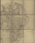
 Antietam. Prepared by Bvt. Brig. Genl. N. Michler, Major of Engineers, from surveys under his direction, by order of Brig. Genl. & Bvt. Maj. Genl. A. A. Humphreys, Chief of Engineers, and under the authority of the hon. Secretary of War. Surveyed & drawn by Maj: J. E. Weyss, assisted by F. Theilkuhl, J. Strasser & G. Thompson. Michler, N. (Nathaniel), 1827-1881. CREATED/PUBLISHED [S.l.], Photo-lith. by the N.Y. Lithographing, Engraving & Printing Co., Julius Bien, Supt., 1867. NOTES Scale 1:21,120. "General direction of Confederate line of battle, Sept. 16th 1862" and "(General direction of) Confederate line of battle, Sept. 17th 1862 (evening)" are hand-colored in red. Union troop positions are not indicated. Detailed map of the environs of Sharpsburg showing roads, the "Washington Co. R.R.," fences, houses, names of residents, vegetation, drainage, villages, the "Burnside Bridge," "Bloody Lane," "Dunker's Chapel," "National Cemetery," and relief by hachures. In this issue, the map is printed on a yellow background with the Potomac River colored green. Antietam. Prepared by Bvt. Brig. Genl. N. Michler, Major of Engineers, from surveys under his direction, by order of Brig. Genl. & Bvt. Maj. Genl. A. A. Humphreys, Chief of Engineers, and under the authority of the hon. Secretary of War. Surveyed & drawn by Maj: J. E. Weyss, assisted by F. Theilkuhl, J. Strasser & G. Thompson. Michler, N. (Nathaniel), 1827-1881. CREATED/PUBLISHED [S.l.], Photo-lith. by the N.Y. Lithographing, Engraving & Printing Co., Julius Bien, Supt., 1867. NOTES Scale 1:21,120. "General direction of Confederate line of battle, Sept. 16th 1862" and "(General direction of) Confederate line of battle, Sept. 17th 1862 (evening)" are hand-colored in red. Union troop positions are not indicated. Detailed map of the environs of Sharpsburg showing roads, the "Washington Co. R.R.," fences, houses, names of residents, vegetation, drainage, villages, the "Burnside Bridge," "Bloody Lane," "Dunker's Chapel," "National Cemetery," and relief by hachures. In this issue, the map is printed on a yellow background with the Potomac River colored green. |
 Antietam. [Prepared by Bvt. Brig. Genl. N. Michler, Major of Engineers, from surveys under his direction, by order of Brig. Genl. & Bvt. Maj. Genl. A. A. Humphreys, Chief of Engineers, and under the authority of the hon. Secretary of War. Surveyed & drawn by Maj: J. E. Weyss, assisted by F. Theilkuhl, J. Strasser & G. Thompson.]. Michler, N. (Nathaniel), 1827-1881. CREATED/PUBLISHED [S.l.], Photo-lith. by the N.Y. Lithographing, Engraving & Printing Co., Julius Bien, Supt., 1867. NOTES [Scale 1:21,120]. Another copy. Stamped at top of map: 320 Union. Handwritten note on verso: War Records Office. Washington, D.C. Feb. 8, 1892. Respectfully referred to the Postmaster, Sharpsburg, Md. with request that he will please examine this map, correct the spelling of the names and return it to me as early as practicable. [Signed] C. D. Cowles, Capt. U.S.A. Confederate positions and the corrections apparently made by the Sharpsburg Postmaster are in red ink. This map was in the possession of Jedediah Hotchkiss at the time of his death. Major Hotchkiss served as topographic engineer with the Army of Northern Virginia. Antietam. [Prepared by Bvt. Brig. Genl. N. Michler, Major of Engineers, from surveys under his direction, by order of Brig. Genl. & Bvt. Maj. Genl. A. A. Humphreys, Chief of Engineers, and under the authority of the hon. Secretary of War. Surveyed & drawn by Maj: J. E. Weyss, assisted by F. Theilkuhl, J. Strasser & G. Thompson.]. Michler, N. (Nathaniel), 1827-1881. CREATED/PUBLISHED [S.l.], Photo-lith. by the N.Y. Lithographing, Engraving & Printing Co., Julius Bien, Supt., 1867. NOTES [Scale 1:21,120]. Another copy. Stamped at top of map: 320 Union. Handwritten note on verso: War Records Office. Washington, D.C. Feb. 8, 1892. Respectfully referred to the Postmaster, Sharpsburg, Md. with request that he will please examine this map, correct the spelling of the names and return it to me as early as practicable. [Signed] C. D. Cowles, Capt. U.S.A. Confederate positions and the corrections apparently made by the Sharpsburg Postmaster are in red ink. This map was in the possession of Jedediah Hotchkiss at the time of his death. Major Hotchkiss served as topographic engineer with the Army of Northern Virginia. |
 Magnus' historical war map. One hundred & fifty miles around Richmond. Magnus, Charles. CREATED/PUBLISHED New York, Washington, Charles Magnus, [1864] NOTES Scale ca. 1:920,000. General map centered on Richmond, Virginia. "Mirror of events [i.e., list of battles] 1861-62-63-64" has been attached to the left of the map. Insets: Maj. Gen. Canby' base of operations [Mississippi and Red River area] 9 x 8 cm.-Maj. Gen. W. T. Sherman's base of operations [northern Georgia] 9 x 8 cm.-Fortifications around Richmond, Va. 12 x 11 cm.-Prominent battle grounds [Bethel, Bull Run, Winchester, Fair Oaks, Seven days' battles, Malvern Hill, Antietam, Chancellorsville, Mt. Crawford, and Monocacy, 1861-64] 10 maps, each 4 x 4 cm. Includes portraits of Generals Grant and Lee. Magnus' historical war map. One hundred & fifty miles around Richmond. Magnus, Charles. CREATED/PUBLISHED New York, Washington, Charles Magnus, [1864] NOTES Scale ca. 1:920,000. General map centered on Richmond, Virginia. "Mirror of events [i.e., list of battles] 1861-62-63-64" has been attached to the left of the map. Insets: Maj. Gen. Canby' base of operations [Mississippi and Red River area] 9 x 8 cm.-Maj. Gen. W. T. Sherman's base of operations [northern Georgia] 9 x 8 cm.-Fortifications around Richmond, Va. 12 x 11 cm.-Prominent battle grounds [Bethel, Bull Run, Winchester, Fair Oaks, Seven days' battles, Malvern Hill, Antietam, Chancellorsville, Mt. Crawford, and Monocacy, 1861-64] 10 maps, each 4 x 4 cm. Includes portraits of Generals Grant and Lee. |
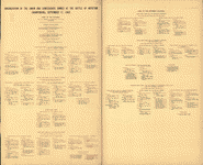
Atlas of the battlefield of AntietamSurveyed by Lieut. Col. E. B. Cope, engineer, H. W. Mattern, assistant engineer, of the Gettysburg National Park. Drawn by Charles H. Ourand, 1899. Positions of troops by Gen. E. A. Carman. Published by the authority of the Secretary of War, under the direction of the Chief of Engineers, U. S. Army, 1904. Cover title. "Organization of the Union and Confederate armies at the Battle of Antietam (Sharpsburg), September 17, 1862": [3] p. (Also in MrSid format.) |
 Title page |
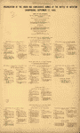 Organization of the Union and Confederate Armies ? |
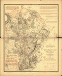 1: September 17, 1862, Daybreak |
 2: September 17, 1862, 6 to 6:20 A.M. |
 3: September 17, 1862, 6:45 to 7 A.M. |
 4: September 17, 1862, 7:20 A.M. |
 5: September 17, 1862, 7:30 A.M. |
 6: September 17, 1862, 8 A.M. |
 7: September 17, 1862, 8:30 to 8:40 A.M. |
 8: September 17, 1862, 9 to 9:30 A.M. |
 9: September 17, 1862, 10:30 A.M. |
 10: September 17, 1862, Noon to 12:15 P.M. |
 11: September 17, 1862, 1 P.M. |
 12: September 17, 1862, 3:30 to 3:45 P.M. |
 13: September 17, 1862, 4:20 P.M. |
 14: September 17, 1862, 5:30 P.M. |
 Title page |
 Organization of the Union and Confederate Armies ? |
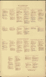 Army of Northern Virginia |
 1: September 17, 1862, Daybreak |
 2: September 17, 1862, 6 to 6:20 A.M. |
 3: September 17, 1862, 6:45 to 7 A.M. |
 4: September 17, 1862, 7:20 A.M. |
 5: September 17, 1862, 7:30 A.M. |
 6: September 17, 1862, 8 A.M. |
 7: September 17, 1862, 8:30 to 8:40 A.M. |
 8: September 17, 1862, 9 to 9:30 A.M. |
 9: September 17, 1862, 10:30 A.M. |
 10: September 17, 1862, Noon to 12:15 P.M. |
 11: September 17, 1862, 1 P.M. |
 12: September 17, 1862, 3:30 to 3:45 P.M. |
 13: September 17, 1862, 4:20 P.M. |
 14: September 17, 1862, 5:30 P.M. |
BalladThe Battle of Antietam Creek - Ford, Warde, performer / 4 minutes 55 seconds |
Antietam Civil War Photo
|
 The "Sunken Road" at Antietam. [Stereograph] |
 Dunker Church, Antietam, Sept. 17th 1862. [Stereograph] |
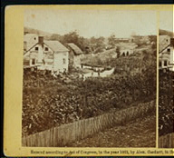
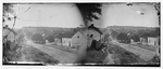 [Sharpsburg, Md. Principal street] |
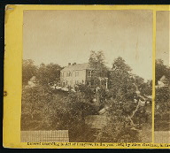
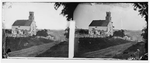 [Sharpsburg, Md. Lutheran church] |
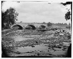
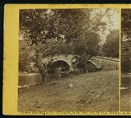
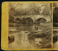
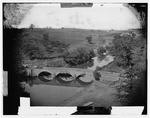
 [Antietam, Md. Burnside's bridge] |
 [Antietam, Md. A cavalry orderly] |
 [Sharpsburg, Md. View with Episcopal church in distance] |
 On the Antietam Battlefield. [Stereograph] |
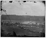
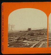
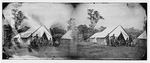
 [Antietam, Md. Battlefield on the day of the battle] |
 [Antietam, Md. Antietam Bridge on the Sharpsburg-Boonsboro Turnpike] |
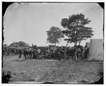 [Antietam, Md. Blacksmith shoeing horses at headquarters, Army of the Potomac] |
 Burnside bridge, from the South-East. [Stereograph] |
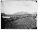 [Harper's Ferry, W. Va. View of the town and railroad bridge] |
 [Elk Mountain, Md. Signal tower overlooking Antietam battlefield] |
 [Berlin (now Brunswick), Md. Pontoon bridge and ruins of the stone bridge] |
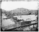 [Harper's Ferry, W. Va. View of town; railroad bridge in ruins] |
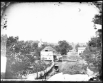
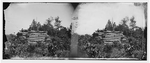
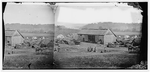 [Keedysville, Md., vicinity. Smith's barn, used as a hospital after the battle of Antietam] |
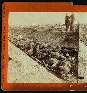
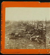
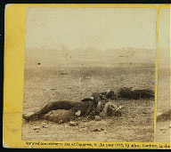
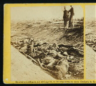
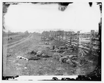 [Antietam, Md. Confederate dead by a fence on the Hagerstown road] |
 [Berlin (now Brunswick), Md. Pontoon bridge and ruins of the stone bridge; another view] |
 Where Sumner's Corps charged at Antietam. [Stereograph] |
The "Sunken Road" at Antietam. [Stereograph] |
Dunker Church, Antietam, Sept. 17th 1862. [Stereograph] |
[Sharpsburg, Md. Principal street] |
[Sharpsburg, Md. Lutheran church] |
[Antietam, Md. Burnside's bridge] |
[Antietam, Md. A cavalry orderly] |
[Sharpsburg, Md. View with Episcopal church in distance] |
On the Antietam Battlefield. [Stereograph] |
[Antietam, Md. Battlefield on the day of the battle] |
[Antietam, Md. Antietam Bridge on the Sharpsburg-Boonsboro Turnpike] |
[Antietam, Md. Blacksmith shoeing horses at headquarters, Army of the Potomac] |
Burnside bridge, from the South-East. [Stereograph] |
[Harper's Ferry, W. Va. View of the town and railroad bridge] |
[Elk Mountain, Md. Signal tower overlooking Antietam battlefield] |
[Berlin (now Brunswick), Md. Pontoon bridge and ruins of the stone bridge] |
[Harper's Ferry, W. Va. View of town; railroad bridge in ruins] |
[Keedysville, Md., vicinity. Smith's barn, used as a hospital after the battle of Antietam] |
[Antietam, Md. Confederate dead by a fence on the Hagerstown road] |
[Berlin (now Brunswick), Md. Pontoon bridge and ruins of the stone bridge; another view] |
Where Sumner's Corps charged at Antietam. [Stereograph] |
 Bridge across the Antietam. North-East view. [Stereograph] |
 Burnside bridge, Antietam, looking up stream. [Stereograph] |
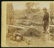
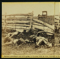
 Confederate soldiers as they fell, near the Burnside Bridge, at... |
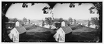
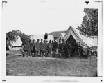 [Antietam, Md. President Lincoln with Gen. George B. McClellan and group of officers] |
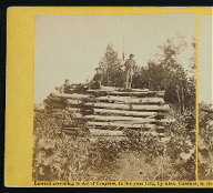 Signal tower on Elk Mountain, overlooking battle field of Antietam. [Stereograph] |
 Ditch on the right wing, where Kimbal[l]'s brigade fought so de... |
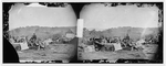
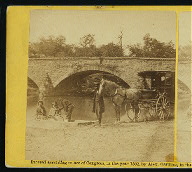 Pic-nic party at Antietam bridge, 22d September, 1862. [Stereograph] |
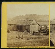 Smith's barn, near Keedysville, used as a hospital after the battle of Antietam. [Stereograph] |
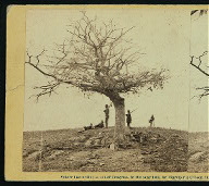 A lone grave on battle field of Antietam. [Stereograph] |
 [Antietam, Md. President Lincoln and Gen. George B. McClellan in the general's tent; another view] |
 View on battle field of Antietam near Sherrick's house, where t... |
 [Keedysville, Md., vicinity. Confederate wounded at Smith's Ba... |
 Straw huts erected on Smith's farm, and used as a hospital afte... |
 [Antietam, Md. Another view of Antietam bridge] |
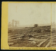
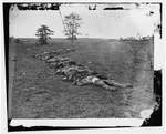 [Antietam, Md. Bodies of Confederate dead gathered for burial] |
 A contrast. Federal buried; Confederate unburied, where they f... |
 A contrast. Federal buried; Confederate unburied, where they f... |
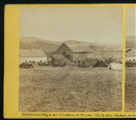 Smith's house and barn, near Keedysville, used as a hospital af... |
 View on battle field. Group of Louisiana regiment as they fell... |
 "The sunken road" at Antietam. A Union battery succeeded in ge... |
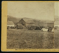 Smith's house and barn, near Keedysville, used as a hospital af... |
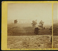 View of battle field of Antietam on day of battle, 17th September, 1862. [Stereograph] |
 View on battle field of Antietam where Sumner's corps charged t... |
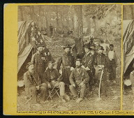 Group, Gen'l Caldwell and staff on battle field of Antietam, 21st September, 1862. [Stereograph] |
 Ruins of Mumma's house, on battle field of Antietam. [Stereograph] |
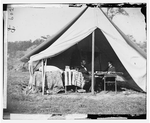
 Gen'l Hooker's headquarters during the battle of Antietam. [Stereograph] |
 [Antietam, Md. Gen. Randolph B. Marcy with officers and civili... |
 He sleeps his last sleep. A Confederate soldier who after bein... |
This is a must have collection for any civil war history buff!
To use this software, you must install the free ExpressView MrSid software which is included on the CD. This is a 30 second process and will allow you to view and manipulate/print all the maps in this CD collection in full detail. There is a version for both Windows platforms and full installation instructions are included on the CD.